News surf Côte Basque & Landes
How to Read the Surf Forecast for Biarritz, Basque Country
21 September 2023
How to Read the Surf Forecast, Basque Country
To start with, we recommend using the Windguru app or website to check the surf forecasts for the Basque Country.
Before you hit the water, it’s important to consider all the factors that could make your session either amazing or a total disaster.
Be careful—it can also happen that you read a great forecast, head to the spot, and then realize the waves aren’t what you’d hoped for.
But to help you avoid any unpleasant surprises, we’re going to share our tips on how to best interpret surf forecasts.
Our article is organized into three main points for each concept discussed.
- the explaination
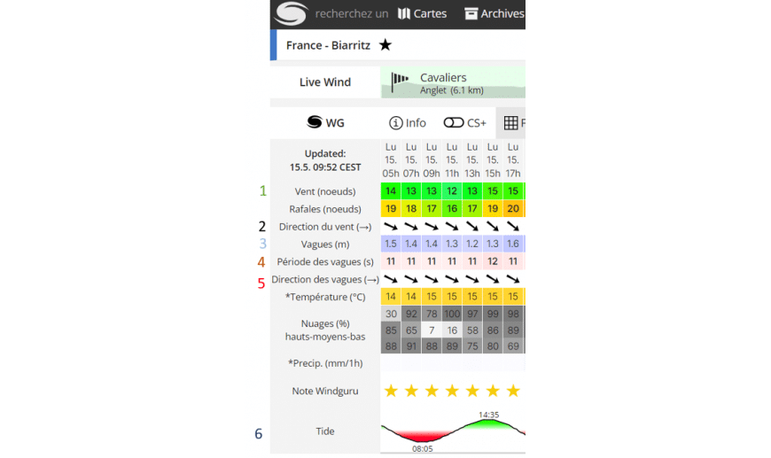
- The example based on the Windguru screenshot (the article starts with point 1, the wind, and ends with point 6, the tide)
- Our advice regarding the topic discussed
1. Wind speed
Sur windguru la force du vent est représentée en nœud et par un code couleur.
White/Light Blue = light wind
Green = moderate wind
Green = moderate wind
Purple = storm
(One knot equals 1.852 km/h)
Exemple :
On Monday at 5 a.m., the wind was 14 knots, shown in green, which means the wind was moderate.
Wind gusts, meanwhile, reached 19 knots, shown in yellow. The wind gusts were therefore strong.
Advices:
You shouldn’t overlook the wind’s strength and direction; it’s a very important factor in understanding the conditions. If the wind is too strong, waves may not form, even if the forecast swell is 1.70 meters.
2. Wind Direction
There are several types of wind:
An offshore wind—one that blows from land toward the ocean—is preferable because it helps generate waves and generally results in a cleaner water surface with higher waves.
An offshore wind will be represented by an arrow pointing to the left.
An onshore wind—one that blows from the ocean toward the shore—can make the waves smaller, choppier, and a bit more disorganized, making it harder to read the waves and position yourself in the water.
An onshore wind will be represented by an arrow pointing to the right.
And the sideshore wind that blows along the beach tends to hollow out the waves and create a current in the water.
The arrows are shown from bottom to top.
Exemple :
In the photo, you can see that at 5 a.m. on Monday, the wind was blowing from the northwest. As mentioned earlier, the wind direction will have a huge impact on wave formation.
Advices :
To understand the wind direction, imagine a photo of the Basque Coast. The Basque beaches are situated in a bay that faces northwest and west, which means that a southerly wind will remain offshore along the Basque beaches and become a sideshore wind along the beaches of the Landes.
3. The waves
Wave height is measured in meters; it actually indicates the size of the swell. A swell is the undulating motion of the sea; it is caused by the wind.
Exemple :
On Monday at 5 a.m., there was a 1.50-meter swell, but that doesn’t mean the waves were 1.50 meters high.
Advices:
Be careful not to assume that swell is exactly the same as wave height. Wave height varies depending on the period and the conditions at each spot.
4. Wave Periods
The period is the time between each wave; it is measured in seconds. The longer the period, the more time the waves have to grow. This information is essential for understanding the size of the waves that will form.
The shorter the period, the closer together the waves will be. This makes it harder to get out to deeper water, and the water will be choppier. Conversely, the longer the period, the less frequent the waves will be, but the water will become smoother because the waves are farther apart.
Keep in mind that if the period is 15 seconds and the forecast swell is 1.50 meters, it is highly likely that the waves will easily reach 2 meters during the sets.
Exemple :
4–7-second period = Few waves, choppy water
9–10-second period = Good waves, clean water
11–15-second period = Great waves, very clean water
Period longer than 15 seconds = Very clean waves but long wait times
On Monday, we had an 11-second swell, which promised some really good waves with very clean water. But we could tell right away that the wind was strong that day, so the waves wouldn’t necessarily be great.
Advices:
Most of the spots along the Basque Coast and in the Landes are beach breaks that generally don’t handle long periods well. When the period is too long, the sandbar can’t handle the swell and produces closing waves (as shown in the photo).

We therefore recommend choosing reef breaks such as Guethary, Lafitenia, or Cénitz, where the seabed is rocky, as this will help you better withstand long periods in the water.
Reef breaks, as the name suggests, are surf spots with a rocky or coral bottom rather than a sandy one.
5. Wave Direction
Most swells in the Basque Country come from the northwest or west. This is generally the swell that works best for surf spots in the Basque Country.
Exemple :
On Monday, the waves were coming from the northwest
Advices :
For your information, in the Basque Country and the Landes region, most waves break from the northwest or west. It is rare to see waves breaking from any other direction.
6. The Tide
It will determine the amount of water in the ocean, which in turn affects wave formation and water depth at different times of the day.
As a general rule, there are two high tides and two low tides each day.
Exemple :
On Monday at 5 a.m., the tide was ebbing and was expected to reach low tide at 8:50 a.m.
Advices :
Beginner surfers are advised to surf at low tide, since the waves will be a little less powerful, they’ll be able to touch the bottom, and there will be less current.
After that, it depends on the spot where you decide to go surfing; there are certain spots that can only be surfed at low tide, mid-tide, or high tide.
So be sure to do your research before you go—even if the forecast looks perfect, you might be disappointed when you arrive at the spot if you haven’t looked into how it works beforehand.